Maps of Scotland show the advancing knowledge of the country as time passed, along with the changing nature of the country itself.
In the past, topographic accuracy was often questionable — mapmakers influenced each other and shared knowledge, often passing on mistakes.
Some maps of Scotland in our 'You are Here' exhibition show mapmakers' changing understanding of the lands they depicted.
The first map of Scotland alone

Visitors to 'You are Here' could view the first published map of Scotland alone.
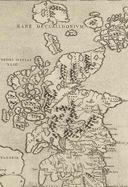
Probably issued in Venice by Paolo Forlani in 1560, 'Scotia' is based on a 1546 map by the English cleric George Lily.
The map was issued as a single sheet, rather than as part of a map of Britain.
Maps from this time were often based upon written descriptions rather than measured surveys. 'Scotia' has been described as 'careless' with its accuracy: Arbroath is placed north of Montrose, and several place names are omitted.
'The naturalist's map of Scotland'

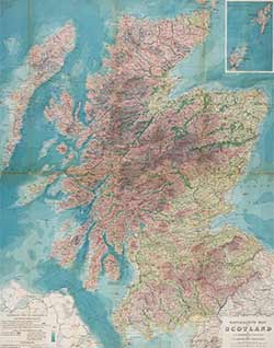
Produced in Edinburgh around 1893, 'The naturalist's map of Scotland' was made by J A Harvie-Brown and J G Bartholomew.
'The naturalist's map of Scotland' shows many natural features of the country, including:
- Cultivated land
- Woodland
- Moorland
- Deer forest
- Salmon rivers and lochs.
The map's colouring reveals the height of the land and the depth of the sea, creating a good reflection of the landscape as a whole.
After the map's publication, Harvie-Brown wrote to Bartholomew to discuss plans for further naturalist's maps, including bird migration lines and faunal regions.
Maps of Scotland were on show in 'You are Here', our exhibition on maps, which ran at the National Library from 22 July 2016 to 17 April 2017.
