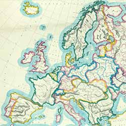
Educational maps of Europe are a representation of history, and an insight into changing international relations.
Visitors to 'You are Here' could observe the changes to Europe from the past 200 years, illustrated through a range of maps on display.
'School room map of Europe'

The 'School room map of Europe' is an educational map which shows international boundaries.
Produced in 1852 by the Scottish School Book Association, this map emerged following widespread unrest across the continent. A series of revolutions swept across many European countries in 1848.
The map's simple layout meets the aims of the Scottish School Book Association, which published low cost, current textbooks. This is one of a series covering the world.
'The Graphic' war map

'The Graphic' war map, London, 1914.
View zoomable image
'The Graphic' war map, 1914, shows important information about First World War Europe as the conflict happened, including:
- The number and type of warships involved in British and German naval fleets
- How many men from each country were on the front line of battle
- How many trained men were taking part in battle
- Fortresses, fortified dockyards and naval harbours.
A British weekly illustrated newspaper, 'The Graphic' was first published in 1869, and ran until July 1932.
During the war, many newspapers issued maps charting the progress of the conflict for the people at home. Developments in printing and communication technology meant that regularly updated maps could be used in the printed news.
Maps of Europe were on show in 'You are Here', our exhibition on maps, which ran at the National Library from 22 July 2016 to 17 April 2017.
