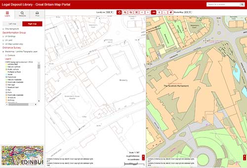
The Legal Deposit Library Modern Map Viewer gives public access to annual snapshots of OS digital mapping. The maps for Great Britain cover 1998 onwards, and those for Northern Ireland cover 2006 onwards.
One important feature of this customised web application is that it lets you view two different years side by side to compare change, as this image shows:

Our Modern Map Viewer is available at the National Library of Scotland within the Maps Reading Room, the General Reading Room, and at Kelvin Hall.
Scales
The map data provides comprehensive coverage of the whole United Kingdom at the largest, most detailed scales available:
- 1:1,250 for urban areas (approximately all towns with more than 4,000 people)
- 1:2,500 for smaller villages and all cultivated rural areas
- 1:10,000 for moorland and upland areas.
Using the application
You can search an area in three ways:
- Zoomable map
- Gazetteer of place names
- Grid reference.
As well as comparing two maps side by side, you can:
- Zoom and pan the detailed mapping
- Measure distances
- Turn contours and grid lines on or off.
Data content — tiles and features
From 1998-2005, we received the OS Land-Line data format, which is based on tiles (squares of varying extent). From 2006, we have received the OS MasterMap data format, which is based on features (buildings, roads, railways, etc.). These features have date information recorded for them, allowing a more specific record of landscape change, and they can also be coloured to create a more intuitive and clearer map.
Layers and contour lines
OS MasterMap includes the Topography and Integrated Transport Network layers, but not the Address or Imagery (aerial photography) layers. You will find further information on OS MasterMap on the OS website.
However, the LandForm PROFILE dataset, from 1998-2014, and OS Terrain 5 from 2015, are included with contour lines surveyed at 1:10,000 scale, and associated height information.
Printouts
We can supply colour printouts at A4 size (on an A3 sheet of paper) for private or non-commercial purposes. You can have up to four copies of the same map extract. See Ordnance Survey's copying information page for more details.
Legal deposit libraries
OS MasterMap has been developed in collaboration with the five other legal deposit libraries in the United Kingdom, who share the same software and map data.
From 2017, the viewer for the data has been enhanced to allow the inclusion of other digital map publications received under non-print legal deposit legislation.
